Summer is the time for hiking, and our beautiful Ticino offers a good number of possibilities. Today, we embark on the discovery of a beautiful itinerary in the Leventina region that leads to a famous hut. Famous because it is no ordinary hut but because it can proudly claim to be the first one inaugurated in Ticino. Infact, we go up to the Campo Tencia hut starting from Dalpe.
A village between meadows and sky
Dalpe is one of the most well-known mountain villages in Ticino precisely because it’s the starting point for numerous hiking routes. A small cluster of buildings reachable within minutes climbing up from Rodi, but it doesn’t reveal itself immediately. Arriving at the point where it climbs, one must first cross a wide expanse of meadow and sky, and then descend to find it lying in a magnificent, smiling basin.
That is its strength, positioning itself on a sun-kissed plateau while being secluded from the rest of the world. Here, the noises of the railway and the highway don’t reach, and as Alina Borioli (1887-1965), one of the valley’s most significant witnesses, wrote about Dalpe, “peace is golden” here.
Climbing up in the Piumogna Valley
But it’s time to lace up our hiking boots and put on our backpacks to tackle our itinerary, which will take us higher, first into the Piumogna Valley, and then, after a beautiful stretch of trail, to our hut.
Signs along the trail indicate a duration of about 3 hours. However, we know that there are mountain running enthusiasts in Dalpe and in the surrounding area who, running at a good pace, can go up in around an hour.
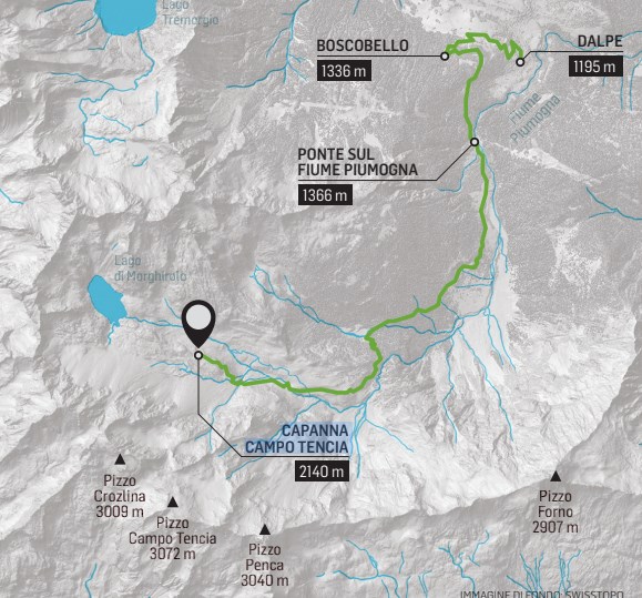
So, we start from Dalpe (1195 m) heading towards Vidresco, and from there, we continue towards “Boscobello” (1336 m), a truly beautiful forest with its tall and slender larch trees, an ideal place for Sunday picnics.
From Boscobello, the dirt road flattens slightly for about two kilometers until we reach the bridge over the Piumogna River. This river has accompanied us with its gurgling in the valley for a while, and now we see it up close, surprised by its already significant flow. Another kilometer, and we find ourselves in the great amphitheater with the imposing rocky walls of Pizzo Crozlina (3009 m), Pizzo Campo Tencia (3072 m), and Pizzo Penca (3040 m) in front of us.
A trail through larch forests
We then continue towards of Alpe di Géra, and before skirting two small ponds, we take the trail that climbs up on the right. This point is well marked by signs; we’re at 1405 m. Here begins the most hiker-friendly section, with the path going up through splendid larch forests.
In the distance, we still hear the sound of the Piumogna River, As well as the impressive stony wall of the Tencia massif does not escape the gaze.
We then arrive at the location of Sgnòi (1650 m), where there’s a little bridge and a crossroad in the path; we continue on the left.
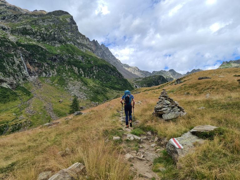
As we go up, the trail, even though well marked, is the one typical of the mountains, a bit uneven with roots and rocks here and there. Until, at a certain point where, after passing through a short staircase that leads to a beautiful garden full of rhododendrons, junipers and blueberries at about 1800 m, the finale stretch begins among wide meadows.
Returning in the evening to Dalpe
After reaching the Campo Tencia hut, you can decide whether to stay overnight, perhaps continuing the next day to other destinations, like the summit of Pizzo Campo Tencia (for experienced hikers) or towards the Leit hut.
Another option is to go back to Piumogna using the same route in the evening: in the initial part in the vast plateau, you might easily spot marmots, whereas in the Piumogna area there are a lot of areas full of mushrooms.
From Piumogna, there are three possibilities to return to Dalpe: descending via the steep “Vallascia” trail located near the bridge, or along the “Calvario,” another path that, despite its name, is not so challenging and branches off to the right side near the chapel of Cimafroda (1370 m).
However, we are returning from where we came, passing through Boscobello again, to descend a bit more and then turn right towards the hamlet of “Cléuro di Dalpe,” which will lead us to the Church of San Carlo, leading us on to the street that crosses the village.
The first hut in Ticino
The Campo Tencia Hut, located at 2140 m altitude, is, as mentioned, the first hut in the Ticino mountains, inaugurated in 1912. On the day of the inauguration, a document was drawn up, which still exists today at the entrance of the structure, describing the origin and purposes of the hut. The text begins with these words: “We inaugurated today, Sunday, the eleventh of August, nineteen hundred and twelve, this alpine refuge in the territory of the municipality of Chironico and in the locality precisely called ‘Giübin,’ for the use of the members of the Swiss Alpine Club and other Alpine societies.”


